On Tuesday, September 29th, the GIS Technology Team at CIC IT Consulting headed a webinar “How to Manage Assets in Utilities Applying the GIS Tool?” that was directed at the utilities sector.
Aurelio Juarez, Sales Manager at CIC, inaugurated the session giving way to Ignacio Peña, Utilities Project Manager, and Tomás Sañudo, GIS Project Manager, who were in charge of the webinar.
The presentation focused, primarily, on 9 success stories, where it was shown that GIS Technology was the perfect ally for the utilities sector.
What is GIS?
GIS, as its acronym would indicate, is a Geographic Information System, designed to gather, to store, to manage and analyse different types of data gathered, and present it geographically referenced in order to help users in the decision making process.
GIS in the Utilities Sector
In the utilities sector, GIS is a very important tool for the implementation of projects because it allows you to:
- Georeference assets
- Implement organizational and maintenance Workflows that meet geographical requirements
- Develop mobility activities and planning of teams and routes.
- Carry out environmental impact studies
- Remote control processes
- Business Intelligence processes, associated with georeferencing and business data
Are you familiar with the challenges and opportunities the utilities sector is facing?
Benefits
The most important benefits GIS provides the Utilities Sector:
- Increased efficiency
- Simplifies production processes
- Optimizes resources
- Increased productivity
- Cost savings
- Effective response
- More accurate decision making
- Promotes competitiveness
- Location management
Success Stories.
After a short introduction of GIS, Ignacio and Tomás presented 9 success stories. A small selection of the most relevant projects was chosen, in which CIC had worked with different technologies: Esri, Google Maps or OpenLayer. As a side note, Esri is the technology that 90% of our GIS projects are based upon.
Below you will find a brief summary of the cases that were dealt with:
Regulatory Information Management System
A system designed to load, analyse, validate and create CNMC report files, as well as carry out calculations and monetize electricity distribution projections. This includes a visual representation module whose files are layered that contain georeferenced information, developed with OpenLayers.
Network Management System
A low, medium and high voltage inventory management system that is a sort of viewfinder, based on Google Maps, the alphanumeric management characteristics of each of its elements and the creation of operational and inventory reports.
Felling and pruning management system
Solutions developed on the ArcGIS (Esri) platform for the generation, planning, execution and follow up of felling and pruning maintenance work, that are in actuality implanted in numerous production environments of the electric sector.
At this point we will introduce two implemented management models. Firstly, based on AT/MT lines or concrete areas that are traced on a map, based on periodic growth of vegetation and the last time it has been cleared, usually one year. Where the company’s assets are based on openings on AT, MT,BT, transformer centers, substations, support and management of any defects in their assets. The second model, designed jointly with Union Fenosa Distribución (UFD) of the Naturgy Group, one of Spain’s largest utilities, was developed according to the clients needs. The maintenance plan, based on a yearly plan and divided geographically into separate areas depending on the type of network or business. A video was shown detailing the felling and pruning model which was implemented by CIC together with UFD
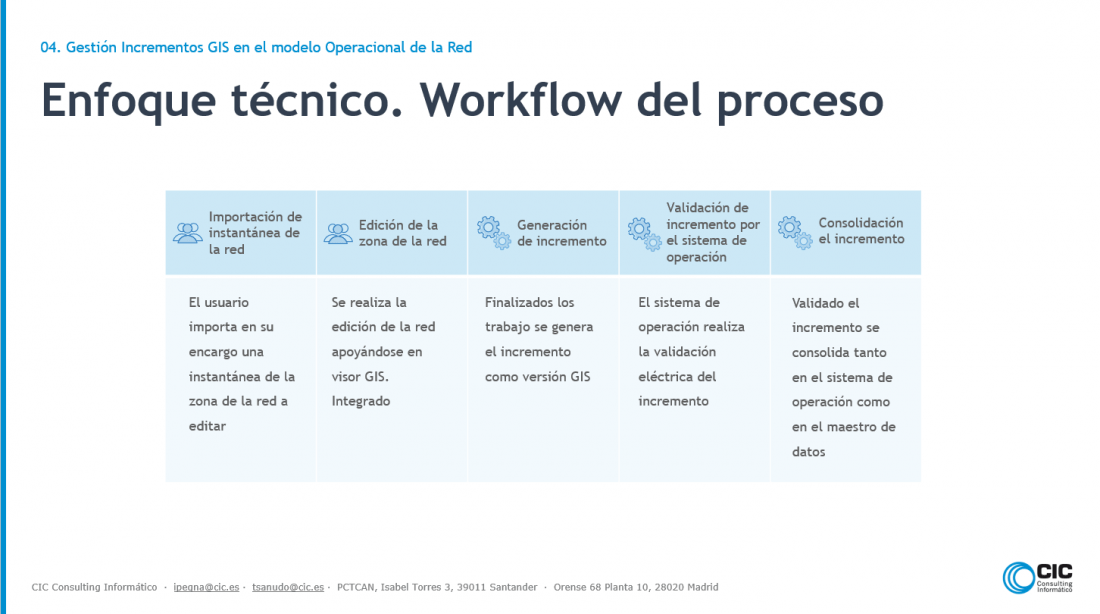
GIS Increment Management in the Network´s Operational Model
A corporate GIS model was shown through a Geometric Network, where all the AT/MT assets guarantee connectivity meeting the topological rules established by the network´s operational system.
BT network management system
The system allows for complete management of the BT network on the basis of the maintenance work on the network, personnel clearance, taking into account the network editing visually and being integrated with mobility tools for the management and resolution of alerts and incidents in the field.
Utility Network
It is the main component and most advanced system users will work with to administer network services and telecommunications ArcGIS (Esri). A recent model , two years old, adds a standard service model for the maintenance of electric, water, gas and telecom networks, that eases and allows, by its structure and modelling, network operational systems integration.
Access to elements of the utility network can be carried out, through web applications or through mobile apps guaranteeing success.
CIC has implemented pilot projects in data loading and data analysis from different data distributors adapted to the Utility network model, one of the most complete points in the implementation.
BIM Models
Modeling buildings from their structure, thereby attaining a three dimensional view of the building, from the construction geometry, georeferenced information, other attributes, such as adjacent structures, with the purpose of localizing assets, interior elements or just wanting an exact three dimensional model of the structure.
Three case studies were set forth, an oil refinery, an electricity substation and, lastly, smart buildings management.
Renewable Energy Parks Management
The project encompasses 450 Renewable Energy Parks Worldwide. The idea is to manage projects in each of its phases: from blueprints, to construction and production. The main objective that the client wanted to emphasize was a normalization of a data model to manage its assets in each of the parks taking into account the different technologies and development phases.
This project was awarded a prize by the World Users Conference of ArcGIS (Esri) in 2016 to the electric company that had implanted it.
Mobility Solutions
Field works to be performed management, traceability of the works, works registry, location and navigation, integration with the rest of the GIS Web components and corporate systems.
The cases presented were directed to maintenance work assets and infrastructures, incident management from the network operating system and as a last success story the presentation of field net capture.
Ignacio and Tomás closed the session answering questions.
We invite you to ask for a demo at [email protected] . We’d also like to let you know that the next GIS webinar will have to do with public administrations. Please follow us on social networks and on our webpage where we will announce the next webinar