A geographic information system or GIS, is a technological solution or software that allows you to visually store, manipulate, analyse, manage and interpret all the data relative to an element situated geographically on a map. Therefore, you can create interactive queries, analyse spatial information, modify data on maps and present reports.
A GIS app or Geographic Information System is a powerful tool that is used in the decision making process, by integrating business data with GIS data, we can clearly see geo-located data on different levels of spatial data.
Thanks to geo-location we are able to see the relationship or tendencies that allow us to take better decisions thanks to geographic coordinates. GIS software developed by CIC allows you to check on a map an element and get associated data from it. In the same way search alphanumerically an element and be able to locate it on a map through mapping.
We develop your custom GIS software application which will allow you visually to simplify the way you manage, distribute and plan territorial resources.
Components of a Geographic Information System
Understanding what geographic information systems (GIS) can do and how it works, a business can decide how to implement it, having previously adapted it to its business needs.
- Geographic Database
The key to a geographic information system is its database. The data can come from different sources: remote sensors, GPS, files… - Software
We develop software that takes advantage of GIS tools for the processing of geographic information. We work with different suppliers, products and GIS platforms like PostGIS (Open Source), Google Maps, and for large bespoke projects ArcGIS by ESRI in which we are highly specialised partners.
Hardware
To be able to visualise and analyse all the data from the geographic information system a computer or hardware is necessary. - Processes
GIS systems need to be well designed, as they are unique, for each business. At CIC we integrate this system in the whole business organisation.
Advantages of a Geographic Information System
The advantages and possibilities that geographic information systems have to offer the business world in analysing data and discovering opportunities are:
- Manage location in cartography through a database with geographic information which is associated with objects on a digital map.
- Manage spatial information. Carry out a complex analysis of spatial reality quickly.
- Facilitate the decision making process at all levels by visualising, understanding, interpreting and analysing geographic data. Faster and easier to determine when to implement actions.
- Understand and deal with a cartographic database. Allows you to compare temporal and spatial situations, calculate routes between two or more locations.
- Integrate and link a large amount of geographic data and tendencies through maps, charts and reports.
- Increase the efficiency of your business projects and reduce production costs incorporating this technology has allowed many companies to better their productivity optimising their resources and reducing costs.
- Promote geographic information technology usage.
Geographic information system (GIS) works as database with geographic information that offer very valuable support to geographically visualise data from remote sensors.
At CIC we have developed a geographic information system for many uses in the real world.
The advantages and possibilities that geographic information systems or GIS afford businesses in the analysis of facts and opportunities is boundless. We are an IT consulting firm that specialises in the design and development of geographic information systems.
- Managing the inventory of a city
- The environment, territorial divisions, parking spots, urban equipment, topographic maps, land registry, mobility, municipal street maps, water resources…
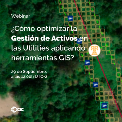
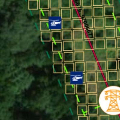
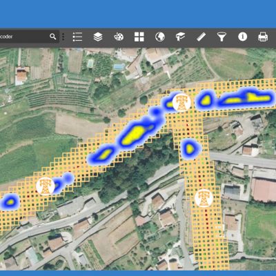
- Management and maintenance of high voltage grids, medium voltage grids and low voltage grids distribution networks
- Assets management and control of construction of offshore platforms
- Inventories in energy renewable farms
- Control of pruning, felling and cutting of trees and vegetation
- Enterprise mobility (FIELDEAS) and monitoring systems (IDboxRT) integration.
At CIC, through Esri Spain we offer solutions in the implementation of geographic information systems (GIS). These are equipped with the necessary tools for the management and dissemination of mapped information. Esri España is the leading distribution company in Spain of GIS: ArcGIS. We also use other platforms such as GIS Open Source and Google Maps.